The Blackbuck National Park is located at Velavadar in Bhavnagar district in the state of Gujarat and is one of a kind in India.
The park spread over 34 sq km is a mix of grass land, shrub land, saline plain and mud flats and is dedicated to the protection of endangered blackbucks.
Herds of blackbucks can be seen across the flat grassland. As per the guide, there were about 1700 blackbucks in and around the park.
Other wild animals like Indian Fox, Indian Grey Wolf, Striped Hyena, Nilgai (blue bull) also call it home.
The park is a good place to watch grassland birds like larks, bushchats, wheatears, sandgrouse, francolins and quails. The park is also known for its winter roost for harriers.
The park is open from 630 hrs to 1300 hrs and then from 1500 hrs to 1800 hrs. The park stays closed during the monsoon - June to October.
At the park you need to take a permit from the forest office at the gate, hire a guide and take your own vehicle in for the safari. The permit, guide and camera cost us Rs. 1000/- on a weekday and Rs. 1100/- on a weekend. The charges are per entry, so if you were doing the morning and evening safari, you're expected to take two permits.
Fortunately, the park isn't exactly a crowd puller, so things like safari jeeps, restaurants, hotels are absent. As per the guide, the forest dept. also keeps things tight by not allowing any of this.
Stay options are limited to The Blackbuck Lodge just outside the park and the rest house (a dormitory and a couple of cottages) run by the Forest Department. The Blackbuck Lodge is super expensive and the forest rest house is difficult to book.
Off the three nights we wanted bookings for, the rest house was available for one night only. When we checked with the Forest Dept. the previous day of our stay, we were told that our room was given to some other govt. official visiting the site!
So stay was organized at Bhavnagar which is about 50 km from the park - about an hour's drive. Bhavnagar has decent cost effective stay options plus the added advantage of some local sightseeing but the hustle bustle of a city.
Takhteshwar Temple, Bhavnagar
The drive from Mumbai to Bhavnagar is about 630 km and takes about 12 hours. The NH48 up to Baroda is nice, though peppered with heavy vehicles that occupy all three lanes and takes about 7 hours. The Baroda - Anand section is fantastic and takes less than an hour. Anand - Velavadar takes about 3 hours on a patchy highway that is being expanded at places. Heavy traffic and cattle keep things slow on this section. Velavadar - Bhavnagar is an interesting one hour drive on a super two lane tarmac flanked by mud flats. Once inside Bhavnagar, traffic is messy in the narrow lanes.
Taking the RORO ferry from Dahej to Ghogha, Bhavnagar, across the Gulf of Cambay, came up as an option from a experience point of view. Though it meant getting out of Mumbai at 400 hrs to get to Dahej by 1100 hrs. The first ferry leaves Dahej at 1200 hrs and you need to report an hour earlier.
Since we weren't sure of our schedule, we hadn't booked the ferry ride in advance. Unfortunately, the ferry was running full that day and we had to settle for VVIP fee of Rs. 3,000/- (against a regular fare of about Rs. 1,700/-) for the two of us and the vehicle.
The ferry started half an hour late that day and took two hours to cross the murky brown waters of the Gulf of Cambay. The embarkation and disembarkation of cars, trucks and buses was handled pretty decently by the ferry crew.
On board, i think two hours is just about the time you can spend walking up and down the vessel, gazing at the horizon, catching a munch at the canteen and snoozing, before it starts getting boring.
Ghogha to Bhavnagr is a 45 minute drive on a patchy narrow two lane with a lot of two wheeler traffic.
Early next day, we got good sightings of blackbucks, nilgai, fox, wolf and hyena at the park.
The guide - Ramzan Khan was good and took us around the park and made sure that we were lined up properly with the light and gaps between the dry foliage from a photography perspective. Though for me it meant handing the camera with a long lens at the ready and taking quick tight turns at the wheel. The Thar's ground clearance and grunt helped.
In Bhavnagar, food at Rangoli and the gujrati thali at Rasoi was very nice. We also sampled some local food - fafda, khandvei and jalebi at the market.
Day two at the park was also decent. Saw a crested serpent eagle while heading to the park in the morning. Another visitor mentioned sighting a pack of four wolves near where the eagle was spotted.
From a photography perspective day two was better. I guess I was better prepared after reviewing the day one pictures and I think the light was better.
Post the safari on day two, we pushed off to Anand to reduce drive distance to Mumbai the next day.
Visited the Amul factory at Anand. Enjoyed the food at Amul Foodland just outside the factory and picked up a load of chocolates from the Amul store.
On the way back to Mumbai, stopped at Legend Hotel at Baroda for a Gujrati breakfast and chai and Hotel Ahura at Talasari for some Parsi Chicken Dhansak for lunch.
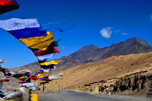
Spiti was on my mind soon after the road trip to Ladakh
in September 2016.
Early June, just before monsoon activity hits the
northern part of the country, looked like a good time for the trip.
Vehicle was serviced. Tires were changed. Tools checked
and sundry winter wear was procured. June being a touristy season, most of the
accommodation along the route was booked a month in advance.
The plan was for the two of us, along with Red Bahadhur, to
drive through the Kinnaur Valley, with a stopover at Sangla, the Pin Valley,
with a stopover at Mudh and the Spiti Valley, with a stay in Tabo and Kaza,
spread over 20 days, including the drive from Mumbai to Shimla and the return
from Manali to Mumbai. This gave us a decent 12 days in the Himalayas.
Star Date 0306 - 0406.2018
The 1,500 km Mumbai – Delhi drive was more or less
uneventful except for the extreme 40 degrees plus summer heat. Fortunately the
Thar’s AC was effective and kept us comfortable.
Somewhere between the Baroda – Udaipur stretch a rubber
hose feeding the intercooler blew a hole. Managed to get to Delhi with the hose
wheezing. Got it replaced in Delhi.
Star Date 0606.2018
Route: Delhi, Chandigarh, Parwanoo, Shimla, Narkanda.
Distance: 443 Km
Time Taken: 12 hrs.
Altitude: 8,900 ft (approx)
Stopped for the customary parathas and chai (tea) at
Murthal in the morning.
Lunch was at Giani Dhaba, which is now on the other side
of the road, at Dharampur and was surprisingly empty. The food though was
decent.
It was cloudy for most of the day. Hit rain short of
Shimla. By evening, after having climbed up to pine tree level, at Narkanda,
the temperature dropped to probably a single digit!
Mahamaya Palace, which is right on the NH was ok for a
stopover. Food at the Negi Dhabha bang opposite the hotel was decent.
Star Date 0706.2018
Route: Narkanda, Rampur, Jeori, Wangtoo, Tapri, Karcham,
Sangla.
Distance: 170 Km
Time Taken: 6 hrs.
After a quick breakfast at the hotel and a fuel stop at
Narkanda, we started for Sangla. The
route through Rampur, Jeori, Wangtoo and Karcham, all along the Sutlej River,
took about 6 hrs.
A landslide at Tapri, short of Karcham, required a
diversion through the JSW Township.
After taking the right for Sangla at Karcham the road
climbs up fast and becomes narrow. The quality of the tarmac though is decent.
The stay at Hotel Mount Kailash was decent. The food was
ok.
The Kamru Fort was a nice 20 minute walk from the Hotel.
Star Date 0806.2018
Route: Sangla, Rakchham, Chitkul and back to Sangla.
Distance: 60 Km
Time Taken: 5 hrs.
Altitude: 11,000 ft (approx)
The plan today was to drive up to Chitkul – the last
Indian village short of the border with China.
Started the drive early and enjoyed the morning chill and
the vistas of the Baspa river valley via Batseri and Rakchham. The road is
decent except for a small stretch short of Chitkul. The drive, which should
have taken about an hour, took about 2 hours because of numerous stops.
The alloo Paratha and Chai breakfast in the early morning
sun was super. Apparently the potatoes grown locally are known for their sweet
taste.
Started for Kalpa from Sangla in the afternoon.
The drive along Karcham, Shongdong and Powari was decent.
Powari had a HP Pump – which looked new.
The drive up to Kalpa via Rekong Peo is a steep climb
with numerous hair pin bends on a narrow well metaled road. While climbing up,
I almost got a feeling that we were leveling up to the snow covered Kinner
Kaillash!
The food at Kinner Villa was lousy, the room though was
nice. The Hotels location affords a good view of the Kinner Kailash.
Walked down to the Kalpa Monastery and the Fort in the
evening.
Enjoyed the Chai and Momo’s at Bryce – a small restaurant
in the middle of Kalpa town run by a Nepali family.
Star Date 0906.2018
Route: Kalpa, Rekong Peo, Khab, Ka, Nako, Sumdo, Gue,
Lari, Tabo.
Distance: 200 Km
Time Taken: 10 hrs.
Altitude: 10,700 ft (approx)
The India Oil pump at Rekong Peo is open 24 hrs and is a
good option to fuel up for the onward journey as the next pump is about 200 km away at Kaza.
Fueled up early and started for Tabo.
The tarmac disappeared at Pangi and stayed rough up to Pooh.
Post the Spiti – Sutlej confluence at Khab, the climb up
the Kazigs is super fun. Got held up for about an hour a little ahead of Kaa
due to road widening work. Stopped for lunch at Nako.
Stopped at the check post at Sumdo, the entrance of the
Spiti Valley, to make the necessary entries at the police barrier and checked
for directions to the Gue Monastery.
The road leading to the Gue Monastery is again narrow and
rough. The Monastery itself is a pretty picture, but the main attraction here
is the 500 year old remains of a Monk who apparently, as per local lore, took
to payers to rid the place of scorpions to establish the Gue village and gave
up life whilst praying. The remains were found by the villagers inside a
chortan a couple of years back, after the chortan cracked open due to an
earthquake.
The 200 Km run to Tabo took about 10 hrs including the
detour to the Gue Monastery.
Tabo turned out to be a quaint little village on the
banks of the spiti river. The major attractions here are the old monastery, the
early morning prayers at the new monastery and the walk up to the caves on the
other side of the highway.
Hotel Maitreya Regency was nice and comfortable, but the
longing for some local food drove us straight to Café Kunzum Top – A small set
up that serves an array of cuisines. The local Tibetan cuisine consisting of
Thukpa, Thenduk, Barley Pancakes, Barley Chocolate Balls, Seabuckthorn Honey was
amazing and kept us coming back for all our meals in Tabo.
Star Date 1106.2018
Route: Tabo, Dhankar, Lahalung, Kaza.
Distance: 82 Km
Time Taken: 12 hrs.
Altitude: 12,000 ft (approx)
A board and a gate off the NH5 mark the climb up to the
Dhankar Monastery which is perched up the hills in the valley.
The monastery overlooks the confluence of the Pin and the
Spiti river and affords a spectacular view of the valley and far away mountain
tops.
A sumptuous Tibetan bread, omlette and chai at a restaurant just outside of the monastery
entrance gave us much needed early morning energy.
After some meditation in the prayer hall and some chit
chat with Lama Tsering, we headed out for the trek to Dhankar Lake.
The hour long trek to the Dhankar Lake turned out to be
pretty exhausting, given the hot sun and
a steep climb up a dusty trail and of course the altitude.
While the drive up to Lahlung was nice, the stay didn’t
look too comfortable, so we headed to Kaza and put up at Spiti Valley hotel
near the Kaza Monastery. The room and food was just about ok, service was slow.
Parking was along the dusty highway. But after a tiring day, a decent room with
hot water and basic dal-sabzi was all that was required.
The fuel pump at Kaza opens at about 830 hrs and closes
by about 730 hrs. Winter timings are different. Being the only pump between
Manali and Rekong Peo, the pump tends to have a line of vehicles waiting to
fuel up, especially in the morning and evening. Payments are accepted in cash
only.
Star Date 1206.2018
Route: Kaza, Mudh.
Distance: 53 Km
Time Taken: 5 hrs.
Altitude: 12,000 ft (approx)
Headed out of Kaza early in the morning and took the
right on the baily bridge for Pin Valley.
The drive along the pin river was nice. Tried the zip line
crossing across the cold fast flowing river with the help of some locals who
explained the working.
Tara Guest house at Mudh, (which is the most organized
stay option in the village) served hot Tibetan pizza for breakfast which was
relished under a warm sun and a super view of the Pin Valley.
Our stay was organized at a nearby newly built guest
house. The stay was comfortable, the food at Tara Guest house was good. The
pre-booking helped else would have had to settle for not so great accommodation
elsewhere.
The evening was spent walking around the village.
Apparently agriculture has moved from barley to green peas, which fetches a
better price.
Post sun down the temperature drop was tremendous.
Star Date
1306.2018
Route: Mudh, Kungri, Kaza.
Distance: 55 Km
Time Taken: 5 hrs.
Altitude: 12,500 ft (approx)
At about 3 am while looking out of the window, I could
see the Milky Way right in front!
We quickly got ready and got out for an amateur go at
astro-photography.
Later in the morning as the sun started to rise, we
stepped out for a walk on a track heading out of the village.
Started for Kaza after a late breakfast.
Stopped at the Kungri Monastery on the way at Gulling.
The stay at Kaza was at the Spiti Heritage. While the
room was decent, the food wasn’t.
Again being tourist season all the good places – Deyzor
and Sakya Abode were fully booked.
Found Deyzor to be a super place – both ambience and food.
We had most of our meals here during our stay in Kaza.
Star Date 1406.2018
Route: Kaza, Kee, Kibber, Chicham & back to Kaza.
Distance: 65 Km
Time Taken: 7 hrs.
Altitude: 14,000 ft (approx)
Started early for the Kee Monastery. We were there by 8
am, just when the prayers start in the new prayer hall. The lamas were kind to
serve us some of their traditional butter tea. The smell and flavor takes
getting used to. Though the cold morning meant that the cup was up for a second
helping of the hot tea.
The service down at the restaurant was super slow. Since
we had to head to Kibber and Chicham settled for some bread, omelet and chai.
Got back to Kaza late in the afternoon.
Star Date 1506.2018
Route: Kaza, Langza, Hikkim, Komic, Hikkim, Kaza.
Distance: 50 Km
Time Taken: 7 hrs.
Altitude: 15,000 ft (approx)
The schedule for today was a drive to Langza for the
Buddha statue and fossils, Hikkim for the famous post office at 14,500 feet and
Komic for the monastery and the fact that it’s the highest village connected
with a motor-able road.
Starting with Langza turned out to be a good idea. One
the road is better than the Kaza-Hikkim road and two you get better pictures of
the Buddha statue early in the day.
Langza to Hikkim and Komic was a smooth dirt track. So
was the Hikkim-Kaza track, though some sections were narrow and steep with a
sharp drop off right up to Kaza on the left! This section really tests nerves
and driving skills.
The Komic Monastery and the ancient Tangyud Monastery
were amazing and the Monks there were kind to show us around.
The café at Komic served some nice sea buckthorn-honey,
Tibetan sandwich and mini barley pancakes with honey.
Star Date 1606.2018
Altitude: 12,000 ft (approx)
Today was an easy day with a visit to the Kaza Monastery,
shopping and lunch at Deyzor.
Stocked up with essentials and fuel for the trip to Chandratal
and then onward to Manali.
By evening the wind started howling and the temperature
dropped tremendously and that made me anxious of the weather and road
conditions tomorrow.
Star Date 1706.2018
Route: Kaza, Rangrik, Kunzum, Batal, Chota Dhara, Chatru,
Gramphoo, Rohtang, Manali.
Distance: 200 Km
Time Taken: 14 hrs.
Altitude: Kunzum Top 15,000 ft (approx)
As soon as the sun started to rise, I stuck my head out
of the window to check things.
It was cold and windy and the mountain tops were covered
with fresh snow!
Packed up and got ready to move all the time running
various scenarios of road and weather in my head.
Deyzor confirmed roads to Manali and Chandratal were
open.
Clouds started to part as we crossed Rangrik. But far up
on the horizon the mountain tops were hidden under dark clouds.
Kaza to Chandratal takes about 5 hours and Chandratal to
Manali is another 5 hours.
Maintained a steady pace (as steady as the terrain
allowed – most of Kaza to Kunzum to Chandratal to Manali is a dirt track or
worse!) so that I have enough time to drive up to Manali in case the weather
stayed tough.
The weather was tough at Kunzum Top. After paying our
respects at Kunzum Mata, decided to head to Manali and skip Chandratal. Even
after crossing the pass, the weather remained windy, cold and cloudy with some rain
dripping down.
On the brighter side I thought that given the cold weather
conditions, the water crossings may not be tough. Traffic too may be sparse.
So took things one at a time starting with a super rajma
chawal at the Chacha-Chachi Dhaba at Battal. We could see an equal number of
travelers digging into rice and mutton curry. This joint is a life saver in an
area with zero habitation right up to Chatru.
From here on the road conditions got tougher. At some
sections there wasn’t much of a difference between the road and the river bead!
The sparse traffic , allowed me to use the entire road to
navigate through boulders, puddles, water crossings and super uneven terrain.
The Thar’s grunt, short wheel base and ground clearance
came in handy. Navigated through the water crossing at Chota Dhara and the ones
between Chattru and Gramphoo without
much of a sweat.
I could see some people who had driven up in a hatch,
struggle with the terrain in this stretch. They really had to take it slow and
watch where they planted their wheels.
By about 5 pm we were at Rohtang which was under a thick
blanket of cloud.
It was raining and there was amazing amount of tourist traffic
on the Rohtang – Marhi – Manali section. The 50km from Rohtang to Manali that
should have taken two hours, took six hours! But that didn’t ruffle me as I was
sitting pretty content having completed the tough Spiti Circuit.
Tips
Start early. It’ll keep you ahead of the crowd
and give you time to handle anything unforseen.
Book accommodation early if heading here in June-July.
To give local food a go, skip booking
meals with accommodation.
Reached Akshi Beach at about 730 hrs after a rock and
roll drive via the NH17 which is under repairs. The twisty section around Poynad
was a good drive though.
Early in the morning with the tide near its high point,
the beach looked pretty unassuming. As the sun came up a little more, flocks of
winter visitors could be seen settling down.
Oyster Catcher
Lying down flat on the beach and crawling up slowly
helped me get close to some of the visitors.
Kentish Plover
Shooter in the open!
There’s a small parking area with some shacks retailing
snacks. There's also a loo and a changing room – not
exactly hygienic though.